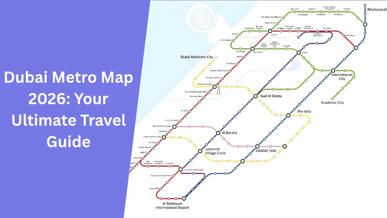
The Dubai Metro Map helps people travel easily in Dubai. It shows all the metro lines, stations, and connections, making it simple to plan a trip. People can use the map to find the nearest station, choose the right metro line, and see important places along the way. Whether you live in Dubai or are visiting, the metro map makes travel fast and stress-free.
The Dubai Metro started in 2009 and has helped millions of people move around the city. Every day, about 730,000 people use the metro because it is quick, safe, and affordable.
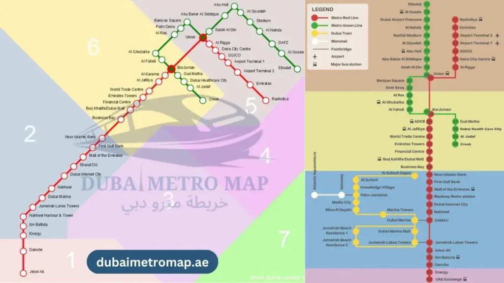
Right now, the Dubai Metro has two main lines:
- Red Line: This line is 67.1 kilometers long and has 35 stations. It connects important places like Dubai Marina, Burj Khalifa, and the Mall of the Emirates. It runs from Jebel Ali to the Sharjah border.
- Green Line: This line is 22.5 kilometers long and has 20 stations. It covers old Dubai, including places like Al Fahidi, the Dubai Museum, and the Gold Souk.
Dubai is expanding the metro to help more people travel easily. The new Blue Line will open in 2029 with 14 new stations and will be 30 kilometers long. By 2040, the metro will have 140 stations and cover a much bigger area.
The Dubai Metro Map makes travel simple and convenient. It helps passengers understand the metro system, avoid confusion, and reach their destination easily. Whether you need to commute to work, visit tourist attractions, or explore new places, the metro map is a great tool to make your journey smooth.
This guide will explain everything you need to know about the Dubai Metro system, including:
- Metro stations and routes
- Ticket prices and options
- How to get a metro map
- Future expansions and new routes
Where to Get the Dubai Metro Map?
You can find the Dubai Metro Map in two ways:
- Physical Copy: You can get a printed map at any metro station. These maps are usually available near ticket counters or information desks.
- Digital Version: You can download the latest metro map from the official RTA website (Roads and Transport Authority). This is useful to check the routes on your phone or computer anytime.
Dubai Metro is one of the best ways to travel in the city. It is clean, modern, and easy to use. Let’s explore how the metro works simply and clearly.
Dubai Metro Overview
The Dubai Metro is the backbone of public transport in the city, consisting of two primary lines:
- Red Line: Covers major business hubs and connects to Expo City Dubai.
- Green Line: Serves historical and residential areas.
Both lines continue to expand, with new routes being planned to meet Dubai’s growing population and infrastructure needs.
Dubai Metro Lines and Extensions
| Metro Line | Launch Year | Number of Stations | Key Expansions |
| Red Line | 2009 | 35 | Extended to Expo City Dubai (2021) |
| Green Line | 2011 | 18 | Fully operational since 2014 |
Future developments include additional extensions and new metro lines to connect more neighborhoods across Dubai.
Dubai Metro Zones & Ticketing
Dubai Metro operates across four main zones, forming part of a seven-zone fare system that determines ticket prices.
| Zone | Coverage |
| Zone 1 | Central Dubai (Downtown, Business Bay, Deira) |
| Zone 2 | Areas surrounding central Dubai |
| Zone 3 | Suburban areas (Jebel Ali, Al Barsha) |
| Zone 4 | Outskirts of the city |
Ticketing Options
| Ticket Type | Details | Best For |
| Single Journey Ticket | Price varies by distance | Occasional travelers |
| NOL Card | Rechargeable card offering discounts | Regular commuters |
| One-Day Pass | Unlimited metro travel for a day | Tourists |
| Monthly/Yearly Pass | Cost-effective for daily use | Frequent travelers |
For updated fares and policies, check the Dubai Metro official website.
Dubai Metro Red Line – Complete Station List
| Station Code | Station Name |
| R11 | Centrepoint |
| R12 | Emirates |
| R13 | Airport Terminal 3 |
| R14 | Airport Terminal 1 |
| R15 | GGICO |
| R16 | City Centre Deira |
| R17 | Al Rigga |
| R18 | Union |
| R19 | Burjuman |
| R20 | ADCB |
| R21 | Max |
| R22 | World Trade Center |
| R23 | Emirates Towers |
| R24 | Financial Centre |
| R25 | Burj Khalifa / Dubai Mall |
| R26 | Business Bay |
| R29 | ONPASSIVE |
| R31 | Equiti |
| R32 | Mall of the Emirates |
| R33 | Mashreq |
| R34 | Dubai Internet City |
| R35 | Al Khail |
| R36 | Sobha Realty |
| R37 | DMCC |
| R38 | Jebel Ali |
| R39 | Ibn Battuta |
| R40 | Energy |
| R41 | Danube |
| R42 | UAE Exchange |
| R70 | The Gardens |
| R71 | Discovery Gardens |
| R72 | Al Furjan |
| R73 | Jumeirah Golf Estates |
| R74 | Dubai Investment Park |
| R76 | EXPO 2020 |
Dubai Tram Line – Key Stations
Dubai Tram connects popular areas such as Jumeirah Beach, Dubai Marina, and Palm Jumeirah.
| Zone | Station |
| 01 | Jumeirah Beach Residence 1 |
| 02 | Jumeirah Beach Residence 2 |
| 03 | Jumeirah Lakes Towers |
| 04 | Dubai Marina Mall |
| 05 | Dubai Marina |
| 06 | Marina Towers |
| 07 | Mina Seyahi |
| 08 | Media City |
| 09 | Palm Jumeirah |
| 10 | Knowledge Village |
| 11 | Al Sufouh |
Dubai Metro Green Line – Key Stations
The Green Line serves historical areas, including Al Fahidi, Union, and Creek.
| Code | Station |
| G11 | Etisalat by e& |
| G12 | Al Qusais |
| G13 | Dubai Airport Free Zone |
| G14 | Al Nahda |
| G15 | Stadium |
| G16 | Al Qiyadah |
| G17 | Abu Hail |
| G18 | Abu Baker Al Siddique |
| G19 | Salah Al Din |
| G20 | Union |
| G21 | Baniyas Square |
| G22 | Gold Souq |
| G23 | Al Ras |
| G24 | Al Gubaiba |
| G25 | Sharaf DG |
| G26 | Burjuman |
| G27 | Oud Metha |
| G28 | Dubai Healthcare City |
| G29 | Al Jadaf |
| G30 | Creek |
Frequently Asked Questions
How do I get a Dubai Metro Map?
You can collect a printed map from any metro station or download it online from the official RTA website.
Can I use a Nol Card on buses and trams?
Yes! The Nol Card works on metro, buses, trams, and even water taxis, making travel easy across Dubai.
What are the metro operating hours?
Monday to Thursday: 5:00 AM – 12:00 AM
Friday: 5:00 AM – 1:00 AM
Saturday: 5:00 AM – 12:00 AM
Sunday: 8:00 AM – 12:00 AM
How much does a Dubai Metro ticket cost?
Prices vary based on distance, but single journey fares start from AED 3, and a one-day pass costs AED 20.
Is there free Wi-Fi on the metro?
Yes! Free Wi-Fi is available at all metro stations and inside the trains.
Conclusion
With a Nol Card and the Dubai Metro Map at your fingertips, you’re ready to explore Dubai stress-free Whether you’re commuting daily or sightseeing, the metro offers a fast, reliable, and affordable way to navigate the city.